


re:invade

Project idea
Many major cities remain intrinsically linked to their rivers, which historically functioned as arterial waterways, fostering prosperity by providing the most efficient transportation routes for goods. However, as urbanization surged, this role gradually diminished, and communities turned their backs on their own waterfronts. Many rivers now endure direct waste discharge from the very villages they once sustained.
Residents of these riverfront cities have increasingly lost touch with the vibrant and dynamic nature of their aquatic spaces. The Nhuệ River has suffered a similar fate. Its banks are now encroached upon by unauthorized residential structures, disrupting the spatial continuity of the waterfront.
Efforts to relocate these informal communities face significant obstacles, ranging from property disputes to broader challenges related to resettlement policies. Lessons learned from previous cases of village displacement highlight that cleaning the river is merely an initial step. Truly reclaiming the waterfront for public use necessitates a holistic approach that accommodates community needs and balances the interests of diverse stakeholder groups. The project's direction focuses on deciphering the intricate relationships among these entities and resolving them through a multi-phase intervention.
The selected pilot study is Cự Đà Village, situated in Cự Khê, Thanh Oai, Hanoi. Cự Đà is an ancient settlement recognized as a historical and cultural heritage site, distinguished by its vernacular architecture and traditional craft industries—specifically vermicelli and fermented soybean paste production. Established over 400 years ago by noble families during the Trịnh Lords’ era, the village—despite its artisanal roots—boasts an array of grand mansions. It was also one of the first areas in Hanoi to have access to electricity. Historically, its prosperity was deeply intertwined with the Nhuệ River, which once sustained a flourishing trade network with bustling boat traffic. However, the severe pollution of the river and unchecked urbanization have radically transformed local livelihoods.
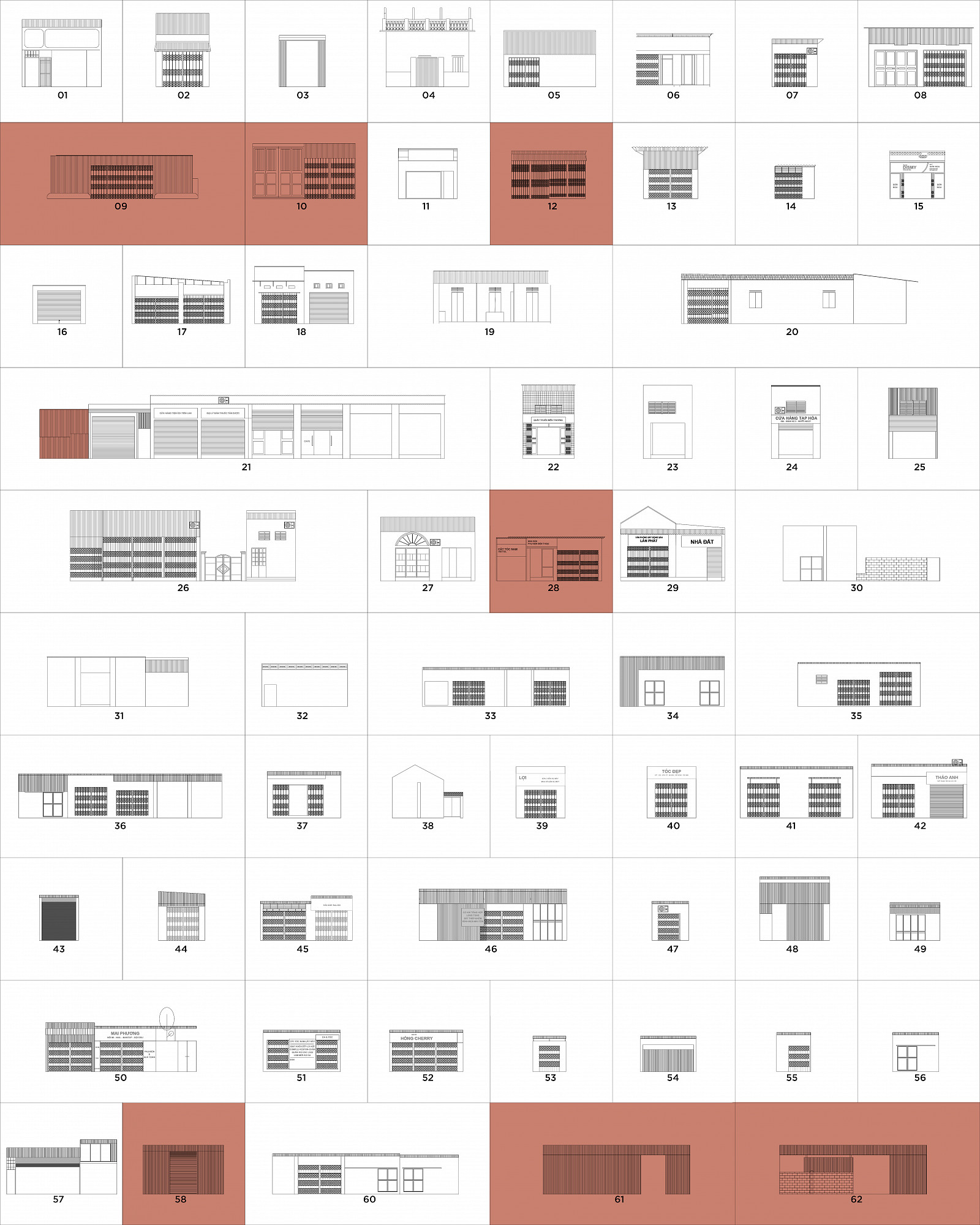
Currently, the urban fabric of Cự Đà exhibits a fishbone transportation layout, closely integrated with the river. Circulation routes run parallel to the waterway, yet visibility is obstructed by unauthorized construction. The spatial composition of the area can be classified into several key elements: the river itself, encroaching dwellings, inner-village residences, heritage landmarks, the intangible legacy of traditional crafts, and the people. The pressure of urban expansion, rising property values, and economic survival weigh heavily on residents, compelling them to seek alternative income sources—often through spatial infringement upon natural landscapes. Increased recreational demands have led inhabitants to repurpose vehicular roads as communal areas, precipitating a series of cascading consequences: the deterioration of heritage structures, abandonment of artisanal trades, migration from the village, encroachment upon natural habitats, and occupation of the riverbed. These compounding factors exacerbate water pollution through the accumulation of domestic and organic waste, rendering the river inaccessible. Tourists have gradually forgotten the village, and local residents have lost their urban memory of a once-thriving waterfront. Although the municipality has proposed a river restoration initiative, reconnecting the community with its aquatic environment requires dismantling the complex socio-spatial dynamics shaping the area.
From this premise, the team presents an overarching vision and intervention strategy:
Architectural theory has long accepted that built environments function as a systemic link in the cycle of natural resource extraction, artificial construction, and eventual demolition, perpetuating a destructive feedback loop that alters the Earth's geological surface and disrupts broader ecosystems. But what if spatial transformations operated within a closed-loop system? What if existing architectural typologies were reorganized into novel morphological assemblages and hybridized programs—offering an alternative trajectory to conventional urban development?
This approach does not merely advocate for recycling but rather the establishment of a mobile, adaptive spatial framework where independent natural and built elements undergo dynamic reconfiguration. Through this process, a new spatial environment emerges—landscape can be embedded within architecture, and architecture can be assimilated within landscape.
The intervention proposes an inversion of existing urban dynamics. What if the relationship of process were to be reversed? What if nature reasserted itself within the built fabric, enveloping historical and architectural layers along the waterfront as a singular entity?
This project aspires to create accessible, multifunctional communal spaces. Instead of residents turning away from their riverfront, everyday commercial and artisanal activities will be reoriented toward the water. The spatial reconnection will unfold progressively—from the riverbank, through informal housing clusters, into public spaces, and ultimately permeating the village core. The initiative aims to restore public engagement with the waterfront, safeguard the livelihoods of informal riverside communities, and enhance accessibility to heritage sites and traditional craft workshops.
Project description
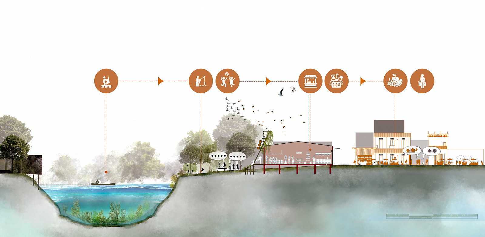
Our objective is to enable nature and the aquatic environment to re-invade and re-establish a harmonious relationship within the project area. This is achieved through two primary components: the Symbiotic Strip and the Transform Void.
Symbiotic Strip:
The Symbiotic Strip is comprised of a lightweight bamboo structure, thoughtfully divided into three zones:
The middle zone facilitates public access and circulation to the river.
The lower zone functions as an aquatic biofilter, supporting the water quality, acting as a soft revetment, and providing a habitat for riparian flora and fauna.
The upper zone serves as a platform for vegetation to proliferate from the Transform Voids and offers shelter for various bird species.
Transform Void:
The Transform Void refers to the interstitial spaces generated after architectural evaluation. These voids enhance community access to the river and serve as anchoring points for greenery. Concurrently, they are designed to host a variety of public village spaces, such as sports grounds, gardening areas, recreational zones, and communal gathering spots.
By treating every element within this scheme as a constituent part of a larger assemblage, even the deep-rooted memories and cultural narratives of the site are considered. As the rearrangement process is activated, countless new configurations emerge, functioning akin to a fluid continuum that allows external nature to profoundly integrate within the village, thereby shaping a harmonious relationship.
The act of movement and interaction between these key voids is crucial in encouraging the community to generate diverse spatial arrangements by relocating objects and activities based on their intended use. These reconfigured elements encompass not only physical aspects (seating, meeting spaces, recreational areas, commercial activities) but also intangible elements (stories of ancient houses, village memories).
Technical information
Our proposed riverside ecological architectural scheme is fundamentally rooted in the principles of modularization and prefabrication. This approach aims to optimize the construction process, minimize impact on existing site conditions, and ensure consistent quality. The entire system is designed as demountable modules, facilitating easy transportation and rapid on-site assembly.
The primary material is bamboo, chosen not only for its indigenous availability but also for stringent technical criteria, notably its low specific gravity and high tensile strength. This lightweight material ensures the scheme fully complies with legal regulations concerning allowable static and live loads on dyke protection corridors.
To guarantee the project's longevity and resilience, all raw bamboo (preferably 3–5-year-old Luồng and Tầm Vông bamboo) undergoes a rigorous treatment process. This process combines traditional methods such as mud soaking and smoking.
From the treated bamboo, the scheme's structure is formed by three main components:
Substructure System: Bioremediation Filter
The first foundation is the substructure system, functioning as an aquatic biofilter. Here, a large-diameter bamboo truss system creates geotechnical boxes, or gabion baskets lined with geotextile fabric. These boxes contain a mixture of soil, sand, gravel, and organic substrate, fostering an environment for aquatic vegetation to flourish. This system is stably anchored to the bank using bamboo piles or melaleuca stakes, simultaneously filtering water and forming a dynamic, soft embankment that protects the riverbank.
Main Circulation and Interaction Space
Developing directly above this infrastructural framework is the project's main circulation and interaction space. Solid or engineered laminated bamboo beams and flooring support the entire deck, calculated to withstand public live loads. The decking utilizes bamboo laminate panels or grooved outdoor natural wood for slip resistance. For safety, a 1.1m high railing system is constructed from vertical bamboo slats, reinforced with mesh or tensioned steel cables.
Uppermost Spatial Structure: Architectural Accent and Bioclimatic Shelter
Reaching the highest elevation, forming the architectural focal point and bioclimatic shelter for the entire project, is the uppermost spatial structure, interconnected at various nodes. This is a lightweight structural system capable of long spans, while also allowing for flexible integration of functional modules such as trellises, water channels, or bird habitats.
To integrate all these components into a cohesive whole, meticulous consideration has been given to connection solutions. These combine traditional bamboo dowels, bolts, and galvanized steel plates at primary load-bearing points, alongside high-strength braided ropes for secondary connections. The assembly process is semi-manual, involving the joining of prefabricated modules from the workshop.
Within the adaptable void spaces, flexible facilities are strategically arranged to meet community needs, including benches, nets, seeds, soil, sand, slides, swings, planters for growing vegetables, and running paths. The new environment will be completed by users themselves, as we have explained above.
Created in:
Copyright © 2025 INSPIRELI | All rights reserved. Use of this website signifies your agreement to the Terms of Use, Privacy Policy, and use of cookies.
