


NATURAL HABITAT PARK - park for the preservation and restoration of the unique nature of the Crimea

Project idea
NATURAL HABITAT PAPK is a scientific and entertainment park for the preservation and restoration of the unique nature of the Crimean Peninsula.
The design site is included in the list of public spaces submitted for rating voting for inclusion in the municipal program "Formation of a modern urban environment of the municipal formation of the Yalta City District of the Republic of Crimea for 2018-2022".
The concept of the project is the preservation of the unique nature of the Crimea, the dialogue between man and nature, the creation of a modern public space that meets the needs of the population.
Keywords: landscaping, coastal territory, sea, world ocean level, global warming, Crimea, prospects, flora, fauna, conservation, restoration, relics, endemics, alternative energy, ecology, innovations, climate resistance.
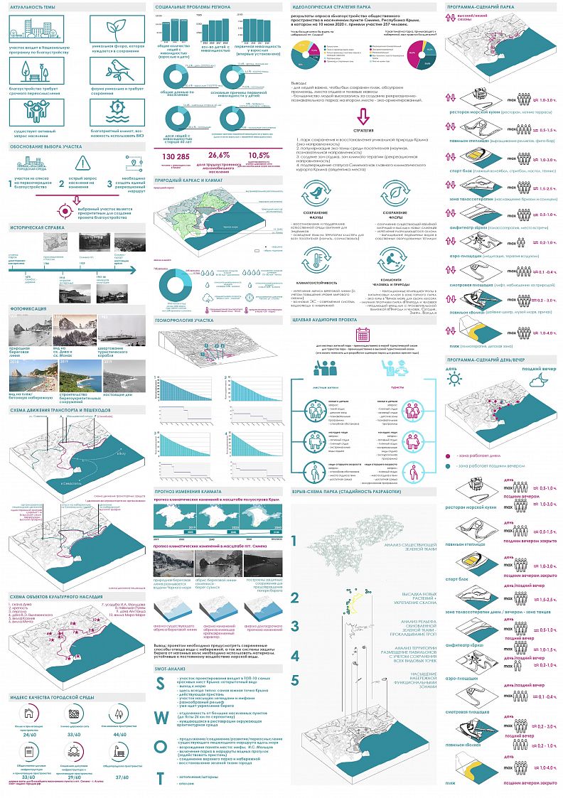
The relevance of the topic of the final qualifying work:
The nature of the Crimea is unique and requires careful attention. It is important to preserve the unique landscape of this territory. The high degree of urbanization of coastal territories entails environmental problems: pollution of the coast, violation of the uniqueness of the landscape.
The problem of global warming entails a rise in the level of the world ocean, which already affects the change in the outline of the coastline of the southern coast of the Crimea (this issue is widely considered in the published article "Prospects for improving the coastal territories of the Crimea taking into account the increase in the level of the World ocean" in the collection of materials of scientific works Modern public spaces as an instrument for the development of the urban environment: materials of the II Interregional Scientific and practical Conference. - St. Petersburg State University of Architecture and Civil Engineering. - St. Petersburg, 2020. – 286 p. Authors: Elena Andreevna Skakunova; Eremeeva Alexandra Fedorovna).
As a result, it is already important to create innovative projects for improving the coastal territories of the Crimean peninsula, which will not only be attractive to people, but also allow preserving the unique nature of the Crimea. The implementation of such projects solves a complex of problems at once: social, environmental and economic.
The goal is to develop a design concept for the coastal territory of the village. Simeiz, taking into account the change in the outline of the coastline, the preservation and restoration of the natural habitat.
Tasks
- to investigate and analyze the geomorphological features of the design area, the climate of the location in dynamics, the flora and fauna of the Crimea, existing social problems, to make a tape of the time of the place and a portrait of visitors; to identify and take into account the code of the place;
- launch a sociological survey "Improvement of public space in the settlement of Simeiz, Republic of Crimea" (the survey can be found at the link: https://forms.gle/GDP1PMqo5QLS5fSA8)
- on the basis of pre-project research and the results of the conducted sociological survey, to develop a project concept;
- to develop a scenario for the use of the park, taking into account the request of the population, the potential of the territory, as well as on the basis of the design program of the park;
- to develop a spatial solution of the design area, taking into account the adaptation of the environment for low-mobility groups of the population;
- to implement the idea of climate stability and environmental friendliness of the environment (climate-resistant building materials and features of spatial organization under the condition of adverse climatic phenomena; energy autonomy and environmental friendliness of the park; preservation of the historical outline of the coastline)
- to develop an educational, scientific and entertainment strategy of the park aimed at preserving and restoring the unique nature of the Crimea.
Project description
The project consists of graphic tablets and a text part, which includes six chapters. The first chapter contains the initial data. The second chapter offers architectural and design solutions. The third and fourth chapters describe engineering and design solutions. The fifth chapter discusses security solutions. The sixth chapter describes the stages of the project implementation.
Technical information
Introduction
Today, one of the priorities in the field of architecture around the world is the creation of comfortable public spaces.
A high rhythm of life, increased stress, poor ecology-all this negatively affects the psychological and physical health of a person. Architects face an important task - to create an environment in which a person will feel comfortable, an environment in which he will want to return again.
In many countries, programs aimed at landscaping are being developed and implemented at the state level.
In Russia, one of such programs is the national project "Formation of a comfortable urban environment", within the framework of which each subject of the Russian Federation creates a list of public spaces in need of renovation and improvement. This is just one of many programs within the framework of economic development for the period from 2018 to 2033.At public discussions on the ground (regions), decisions are made on the priority list of spaces for landscaping. Projects to create a comfortable urban environment are being actively developed and implemented throughout the country. At the same time, an urban environment quality index is being monitored and calculated at the federal level, which allows us to see the dynamics of improvement, make comparisons, and build a further strategy for improving public spaces.
This program also applies to the Republic of Crimea. Today, landscaping on the peninsula can be described as post-Soviet, which does not meet modern requirements for a comfortable urban environment. In this subject of the Russian Federation, an acute demand of the population for changes in the field of landscaping has been revealed.
In this region, the implementation of the program solves several tasks simultaneously:
- improving the level and comfort of life of the population of the peninsula
- solving social problems (socialization of MGN, reducing the crime rate)
- increasing the tourist flow and, as a result, economic growth in the Republic.
The development of landscaping projects is always influenced by the location of the design site, its features. It is important to understand the ecological situation on the territory, the dynamics of its changes, in order to create a place that is comfortable not only for people, but also for nature. The project should fit seamlessly into the environment, without disturbing its microclimate, but only improving and preserving it.
A modern architect should not create a project, but a place.
The nature of the Crimea is unique and requires careful attention. It is important to preserve the unique landscape of this territory. The coastline of the peninsula is a line of attraction for tourists, ships( port), developers. The high degree of urbanization of coastal territories entails environmental problems: pollution of the coast, violation of the uniqueness of the landscape.
The sea also poses a danger to the Crimean coast. The problem of global warming entails a rise in the level of the world's oceans, which already affects the change in the outline of the coastline.
As a result, it is already important to create innovative projects for the improvement of the coastal territories of the Crimean peninsula, which will not only be attractive to people, but also allow preserving the unique nature of the Crimea. By implementing such projects, a complex of problems is solved: social, environmental and economic.
Natural and climatic analysis
- Climate analysis
The design site is surrounded by mountains and rocks: sk. Panea, sk. Diva, G. Koshka. On the southern side, the plot is washed by the waters of the Black Sea. The air of the Crimea is unique – it is clean, not dusty, saturated with phytoncides. This creates a therapeutic effect.
The sea air is saturated with ozone and phytoncides, as well as iodine. The most useful air can be considered (ionized), which is enriched with an electric charge of waves.
The Crimean peninsula covers an area of 26 thousand square kilometers (195 kilometers from north to south, and 325 kilometers from west to east) and covers five climatic zones: continental steppe, coastal steppe, foothill forest – steppe, mountain forest, sub-mediterranean.
Here, nature has created unique conditions for treatment and recovery.
The number of sunny days in a year is comparable to the number of days in Mediterranean resorts. There are 60 rainy days a year in Simeiz (in Yalta, for comparison, 80). And almost all rainy days are observed from October to April (Fig. 10).
- Climate change forecast
The Crimean Peninsula is in a danger zone due to rising sea levels. According to scientists, the territories in the north-western part of the Crimea will be the first to be flooded [2], however, the territories in the south of the peninsula, where the urban-type settlement of Simeiz is located, are also in danger – sea level rise in combination with a surge wave becomes a threat to the entire coastline of the peninsula. However, it should be noted that scientists ' forecasts regarding the problem of sea level rise and the consequences of this differ, but despite this, no one can deny the existing threat. Yes, today we do not observe a steady rise in sea level on the Black Sea coast to critical levels, but it should be remembered that with the rise of the world ocean level, the probability of surge waves, short-term flooding and other problems that entail the temporary or long-term loss of some parts of the land increases. Today, work is underway on the construction of coastal protection structures on the territory of the urban-type settlement of Simeiz, which will save the coastline from the destruction that has begun, but will not help with sea level rise. For Simeiz, the most urgent problem is precisely the change in the outline of the coastline. If we look at its changes in dynamics, it becomes clear that this problem is progressing over time (Fig. 11).
- Natural framework
Simeiz is the southernmost point of the Crimea. The village is located in the subtropical zone of the Crimea at the foot of the Mountain Cat Nature Reserve, Panea Rocks and the symbol of the village is Diva Rocks.
Simeizsky Park adjoins the design site from the west.
In the eastern part, through the descent of Maltsov, there is Maltsov Park.
To the north-west and north-east of the design area there is a residential building with intra-block landscaping (Fig. 12). From
the south of the design area, it is bounded by the waters of the Black Sea.
- Geomorphology
Simeiz is located on the Black Sea coast, at the foot of Mount Koshka, the height of the village center above sea level is 60 m. Mount Koshka itself is located at 254 meters above sea level.
Mount Koshka in Simeiz is a part of the southern Limensky Ridge. The correct name is "Stavri", which means "sharp" in Turkic. If you look at the ridge of Mount Koshka, then it can be called "sharp". This toponym is written in old books that are dedicated to Simeiz.
The Limensky Ridge descends from the foot of the Main Ridge of the Crimean Mountains to the sea, from north to south.The Sevastopol — Yalta highway now passes through an artificial pass near the tail of Mount Koshka. A little higher and to the north, under the cliffs of the Main Ridge of the Crimean Mountains, there are tuff cliffs and the Abitova Polyana tract. Beyond the Limensky Ridge, the Ai-Petrinskaya yayla is located above Simeiz.
On the coast, near Mount Koshka, there are unique rocks of Simeiz. Panea (Genoese rock-Genevi-Kaya and Swan's Wing (the former name of the Estuary-Kaya-rock near the bay). Nearby stands the symbol of Simeiz-the Diva rock. At the foot of the Diva there was a Monk rock-a pointed rock resembled the silhouette of a monk. But it was destroyed and today you can only see the base and blocks of rocks (Fig. 13).
SWOT analysis
SWOT analysis for a landscaping project is a way of strategic planning. This method is effective for identifying strengths and weaknesses, opportunities and threats associated with the features of the design area, planning the stages of project implementation.
SWOT is an abbreviation consisting of the following concepts:
S (Strengths) — strengths, unique characteristics of the design area that favorably distinguish it from others;
W (Weaknesses) — weaknesses that make the design area less profitable from the point of view of project implementation here;
O (Opportunities) — opportunities, that is, what the design area stores, what can be used for a unique and necessary project;
T (Threats) — threats are those elements that can negatively affect the development, implementation of the project, something that you need to think about eliminating when designing.
SWOT analysis for the selected design area:
S (strengths):
- it is included in the TOP 10 most beautiful places of the Crimea, "postcard view";
- there is access to the sea
- the southernmost point of the peninsula (it is always warm here);
- there is a working pier (marine logistics)
- the site is full of legends and myths, many films were shot here;
- characteristic relief;
- by October 2020, the contractor will complete the construction of coastal protection structures;
W (weaknesses):
- remoteness from large settlements (to the city of Yalta 26 km. along the serpentine);
- the surrounding architectural environment in need of restoration;
O (features):
- development of the existing pedestrian route along the sea;
- reviving the memory of the place;
- inclusion of the park in the routes of sea trips;
- connection of the upper park and the embankment;
- connecting the" green fabric " of the city;
T (threats):
- flooding of the embankment/storms;
- landslides.
Conclusion from the SWOT analysis: the selected design area is unique both from the point of view of history and from the point of view of natural and climatic characteristics; it is necessary to pay attention to possible climatic and geological threats (flooding, landslides); it is important to identify the identity-forming meaning for the territory.
Concept-scenario of the design territory
In order to identify an objective request of the population, a survey "Improvement of public space in the settlement of Simeiz, Republic of Crimea" was launched, in which 259 people took part on May 15, 2020. The survey revealed the following:
- unwillingness to see shopping malls and large nodes with sports on the coastline-the theme of the park is important, while a firm orientation on the eco-theme, scientific, informative nature is revealed, the Park for the preservation and restoration of the unique ecosystem of the Crimea will become a place of strength, a point of attraction for visitors of different age and ideological categories. Simeiz will confirm its status as a climatic resort - natural therapy zones will be created.
Conclusions:
- it is important for people that the beach is preserved, the promenade, recreation areas and shade canopies are equipped
- the majority of people supported the creation of a recreational and educational park; in second place - an eco-oriented park.
Concept:
1. Park for the preservation and restoration of the unique nature of the Crimea (eco-orientation)
2. popularization of the eco-theme among visitors (scientific, educational orientation)
3. creation of recreation areas, climate therapy zones (recreational orientation) 4. confirmation of the status of Simeiz as the main climatic resort of the Crimea (identity of the place).
The project is aimed at:
- restoration and maintenance of the natural habitat for endemics - coverage of the topic on the territory of the cluster for all visitors (to study, to participate)
- preservation of the existing "green matrix" and planting of new seedlings
- strengthening the slope - growing endemic species in your own greenhouse
- strengthening of the outline of the coastline (taking into account the increase in the level of the world ocean) - wave power plant - modern drainage system from the embankment
- recreational "floating" trails in cypress alleys - eco-tours to the Black Sea for garbage collection - scientific program of the park "Nature and Man" - selling brand book with an educational theme " Nature and man. Today. Tomorrow. Always."
Target audience:
The main two groups of the target audience are:
1. local residents (features: - Crimeans are characterized by low activity in public places during the high tourist season, since for local residents summer is a time of active work, renting housing, providing tourist infrastructure; you can only notice young parents walking with children - local people also practically do not go to the sea in summer - active visits to local parks and other public spaces occur from the second half of autumn until the beginning of spring)
2. tourists (features: - the tourist season is late spring-early autumn - it is important for tourists to have quick, comfortable access to the beach - in the evening, when the beaches are closed - cafes, restaurants, a promenade on the embankment are in great demand - for tourists with children, it is important that there are children's recreation areas, animators. - the park is interesting for tourists in the afternoon and in the evening, in the afternoon-most on the beach).
The park is open all year round. The infrastructure of the park involves the creation of 30 permanent jobs:
10 workplaces - Volna Pavilion;
10 jobs – restaurant;
5 workplaces - Greenhouse pavilion;
3 workplaces - multi-pavilion;
2 workplaces - control, maintenance of the territory;
As well as 20 seasonal jobs:
3 jobs-beach (lifeguard, medical worker, security);
10 jobs-animators for children;
5 jobs - taking care of the territory;
2 workplaces-security
In the low season, the working time of the functional zones is reduced. Regional and all-Russian events (forums, conferences) are held to attract visitors. During the high tourist season, the schedule of the functional zones depends on the number of tourists.
Daytime and evening activity of the park.
All zones are open during the day. Closed late in the evening:
1. Pavilion "Greenhouse"
2. sports block
3. the beach
Depending on the time of day, the amount of time spent on a particular zone changes. During the day, both the park area on the slope and the embankment are active. In the evening, the zones located on the embankment are more active - there are more lighting and people here. Evening cafes and restaurants are open here, dance floors work, it is cozy to watch the moonlight path and the stars from the Breeze amphitheater.
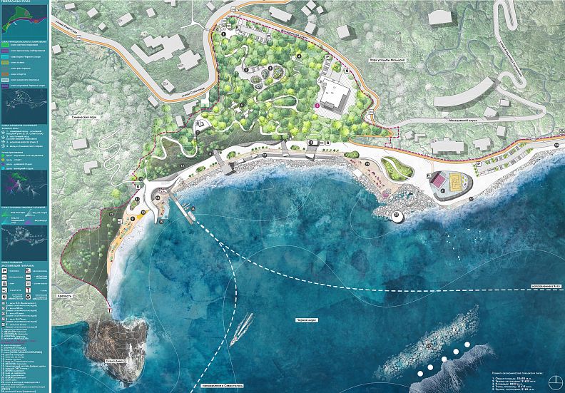
Master plan
The basis for the development of the general plan of the design area was the functional zoning, developed on the basis of the analysis of existing scenarios for the use of the territory, existing hiking trails, places of spontaneous Parking.
Three main areas of the park:
- the Black Sea water area (coastal territory);
- embankment;
- mountain park.
There is an active pier in the Black Sea water area today, as well as piles from the destroyed pier are located to the west. A small pier building was located nearby on the embankment. These historical markers served as the basis for the creation of one of the main nodes of the park – the "Wave" pavilion with the use of the existing pier (with reinterpretation) and the remaining piles.
The pavilion has a bio-shape in the plan, reflecting the idea of a wave. The south-western "tail" of the pavilion follows the trajectory of the destroyed pier.
One of the links "embankment-mountain park" was a path descending from Simeiz Park to the exploited roof of the Volna pavilion.
In a quiet impassable place, near the Diva rock, there is a beach with a fortified slope and the necessary beach infrastructure (a rescue tower, bathrooms, changing cabins, a shower, a medical center, a storage place for sun beds, a beach bar and a children's area).
To the east of the Volna pavilion is the entrance to the elevator tunnel, which lifts visitors to the highest point of the mountain park – the main observation deck of the park is located here, from where an amazing view of the Black Sea opens. Several trails lead from the observation deck to the main areas of the park.
The complex of the northern entrance zone includes a public transport stop, two pedestrian crossings from nearby residential quarters, a parking lot for visitors, a pedestrian sidewalk. Navigation and information stands are located on the site of the entrance area.
The main eco-trail leads from the northern entrance area, descending along the relief to the embankment. Along the way there is a "Multi-pavilion" and a "Greenhouse", passing below you can get off on the path leading to the eastern part of the park, where the tower "Fauna" is located, lost among the crowns of trees. Also, from the main trail, you can go to the entrance to the Seafood Restaurant (the estate of I. S. Maltsov).
Then descend to the embankment.
The "Breeze" amphitheater, located in the southern part of the design area and adjacent to the Black Sea, is torn by platforms at the embankment level. There are three such sites:
- before exiting the elevator tunnel;
- before descending from the mountain park;
- along the axis with the seafood restaurant.
The path leading from the Restaurant leads to the roof of the bar on the embankment, located in an artificially created hill. A descent to the embankment is provided from the roof.
To the east, on the embankment, there is a thalassotherapy area with sun beds overlooking the sea. In the evening, this area works as a dance floor (sun beds are removed to the storage room).
Then there is a sports block, which has a playground for streetball, beach volleyball, table tennis tables, exercise equipment, rental of surfboards, sea bikes, sailing boards, bike rental. A descent into the water is provided. Due to the difference in terrain, it became possible to place the sports block opposite the building located on an elevation.
The strategy for the development of the territory of Bolshaya Yalta provides for the laying of a bicycle path along the street. Soviet. The project takes into account this plan and additionally provides for the laying of a bike path from the street. Go along the Maltsovsky descent to the embankment (to the bike rental area).
A Techno pavilion is located on the stone ridge, in which the substation of the float wave power plant (PVPP) is located. The PVPP is located in the south-eastern part of the Black Sea water area.
The final zone of the eastern part of the design area becomes a parking lot for park visitors, information stands, an alley of palm trees in tubs. The possibility of developing the embankment is provided (Fig. 19).
2.4 Innovative technologies
The project uses several innovative technologies:
- energy independence of the park (the PVPP is located, which generates 75-80% of the electricity needed to provide the park
- desalination plant (there is a small desalination plant in the Techno-pavilion, the water goes to the technical needs of the park)
- local cooling (there are installations located on the territory of the park that help visitors to endure hot weather)
- vacuum waste disposal (modern eco-friendly waste disposal system)
- eco-pier (the pier accepts only tourist vessels and yachts on biofuel)
- drainage of water from the land back to the sea (in the area of the amphitheater and on the embankment there are water intake grilles that divert water to the sea through a special cleaning filter).
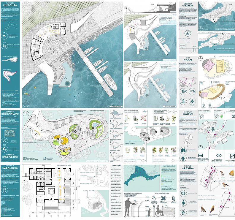
Design and ideology of pavilions
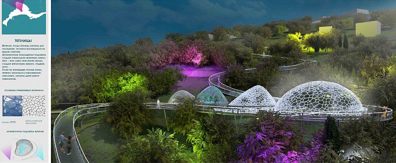
- Pavilion "Greenhouse"
Laboratory for the protection and restoration of flora.
(endemics, relics – a greenhouse and a laboratory for the restoration and reproduction of plants + an educational program in the pavilion - for all visitors to the parks: excursions, practices, a shop and an electronic herbarium)
The image of the pavilion is a plant cell-chloroplasts (the shape forms the basis of the pavilion shell).
The shape of the pavilion is a smoothed inclined truncated cone (the shape is due to research in the field of developing the most correct one from the point of view of the shaping function).
Greenhouse, plants + water tank-80 sq. m.
Mini-laboratory (exhibition) + office for employees-32 sq. m.
- Pavilion "Volna"
This is the center for the study and purification of the Black Sea.
There are: scientific diving, a mini-laboratory for water analysis, sightseeing tours for cleaning the Black Sea-garbage collection; programs, master classes for making art objects from marine debris; exhibition spaces) (fig. 21).
- The Fauna Pavilion
This is a tower with platforms, an electronic laboratory for restoring fauna.
A small tower where you can listen to the recorded singing of birds-relics of the Crimea in solitude, feel the fluttering of butterflies. The tourist has the opportunity to take under the patronage of one of the birds or a kind of butterflies; a relaxation zone with birdsong.
A tower among the trees is an image-a house for birds.
- Pavilion "Aero-platforms"
This is a multi-level open-air zone about the study of the air. There is an aerometer here - with installed air monitoring and measurement devices.
The platforms are located at different levels in relation to each other and have a different area (from 6 to 9 sq.m. – a variable area as a prototype of different – sized atoms of the air molecule)-give the opportunity to enjoy aerotherapy with a view of the sea alone or in the company of 1-2 people.
The image is an air molecule.
The core of the zone is a platform of 25 sq. m – - an aerometer is installed here (the area of the site implies a crowd of people who disperse along the aero-platforms, or leave along the transit path.
- The Techno Pavilion is
located on a stone ridge-further from the recreation areas.
(the pavilion on the coast, where the energy is transmitted from the wave ES – here it is interactively shown how the energy conversion process works)
The pavilion area is 140 sq. m.
There is a wave ES substation (hydroelectric generator) and a small desalination plant.
Excursions are provided here to get acquainted with the technology of the wind farm and the desalination plant.
- Pavilion "Multi"
There is a lecture hall and a coworking space here. The zone works for the entire park.
There are playgrounds located on the territory of the park:
- heliotherapy (a playground with sun loungers for sunbathing and a beach area);
- thalassotherapy (sites in close proximity to the sea - sea therapy, recreation-the "Breeze" amphitheater).
Electricity supply (based on alternative energy)
One of the main strategies of the project is to create an eco-friendly, climate-resistant space.
This strategy is reflected, among other things, in the installation of a wave float power plant in the south-eastern part of the Black Sea.
The wave energy can be used to generate electricity, transfer and desalination of water. The power of waves is an inexhaustible source of energy. The excitement (its power) is estimated as kW/m. If we compare it with solar and wind energy, then the wave energy carries the greatest specific power. The average power of the sea waves passes the mark of 15 kW/m. If the wave reaches two meters, the power reaches 80 kW/m.
Therefore, the coastal zone can be used to install a system for generating electricity from wave energy, which will be used to provide the adjacent park designed in the final qualifying work on a rocky terrain, part of the energy can go to the citywide network. The scheme of operation of the wave power plant is simple and effective. Such a public space meets the standards of eco-friendly construction.
Thus, the prospects of improvement of the coastal territories of the Crimea are revealed. Despite the threat of sea level rise near the coastal territories of the Crimea in the north-western parts, as well as the change in the outline of the coastal south-eastern line, modern technologies make it possible to create "climate-sustainable" landscaping. The advantage of designing near the coastline and directly on it is shown – it is possible to provide structures that generate electricity from the force of waves. The use of regenerative energy is also an urgent and important direction, which is increasingly being introduced into projects for rethinking territories.
The location of the power plant in the project was chosen taking into account the wind rose - the predominant winds blow from the south-east side-therefore, waves in this direction are more frequent than in others. The internal processes of the Black Sea (currents) also affect the strength of the waves in this direction. Thus, the waves in this direction have the greatest kinetic energy. The efficiency of the wave of the float power plant located in this place will be the greatest.
On the stone ridge in the south-eastern part of the design area, a techno-pavilion is provided, into which a low-voltage cable from a wave float power plant is connected, there is a converter of kinetic energy into mechanical energy, a desalination plant, a mechanism for reversing water movement, an electronic device for monitoring the operation of the VPP.
The design area is initially connected to the citywide power grid, but taking into account the installation of the VPP, the energy intake from the citywide network is reduced by 4 times, since 85% of the necessary energy for the park is produced by the VPP.
Conclusion
Design concept of the park and the embankment in the village. Simeiz has been developed taking into account the current regulatory requirements and recommendations.
The park for the preservation and restoration of the unique nature of the Crimea " NATURAL HABITAT PARK "is a modern reinterpretation of public space that answers current issues and problems (climate change, nature conservation," dialogue " between man and nature).
Copyright © 2025 INSPIRELI | All rights reserved. Use of this website signifies your agreement to the Terms of Use, Privacy Policy, and use of cookies.
