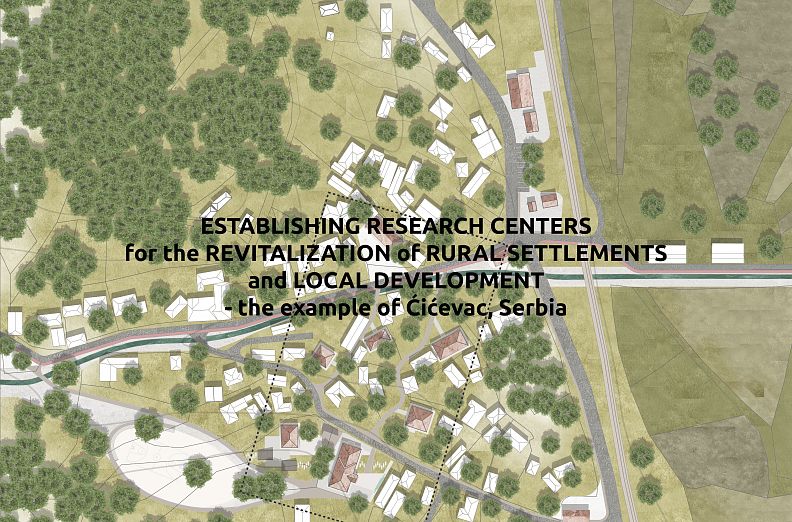

ESTABLISHING RESEARCH CENTERS for the REVITALIZATION of RURAL SETTLEMENTS and LOCAL DEVELOPMENT - the example of Ćićevac, Serbia

Project idea
The aim of the project is to revitalize, connect and develop existing natural and built units by regenerating space and introducing new content and activities.
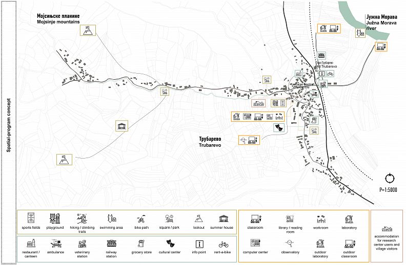
The spatial scope of the project is the village of Trubarevo, which is located in the south of the municipality Ćićevac. With all its qualities and diversity of terrain and natural facilities, Trubarevo has great potential for the development of various contents and activities.
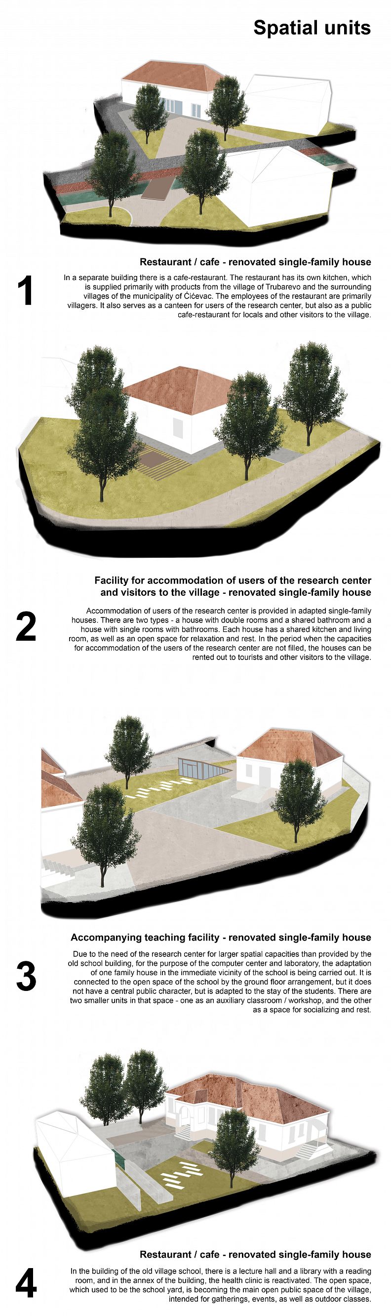
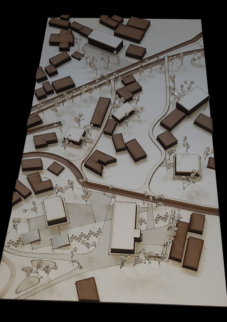
The combination of spatial units forms a complex in which the teaching center located in the existing building of the primary school in Trubarevo is the central one object. Accompanying facilities such as a place to eat are accommodated in the existing village houses and accommodation or additional space for teaching activities. The contents are distributed as well they combine according to the capacities of the given village houses, while the village school is a fixed element complex.
By combining the existing and introducing new contents, purpose zones are formed. With their diversity and overlaps, life in the settlement gained in quality and new opportunities for development open up. Intended purposes are: housing, education, sports and recreation, service activities and traffic.
VISION
Regionally competitive and affordable Trubarevo, spatially-functionally integrated into the environment, protected natural and cultural heritage. Trubarevo with high sustainability and prominent identity.
ANALISYS OF THE CURRENT SITUATION
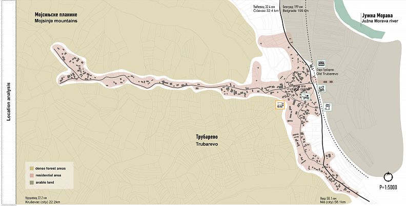
Position on the (left) bank of the South Morava river, in the valley between the hilly terrain of the Mojsinje Mountains represents limiting factor in the spatial disposition of the settlement.
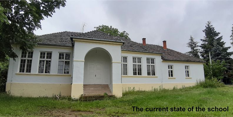
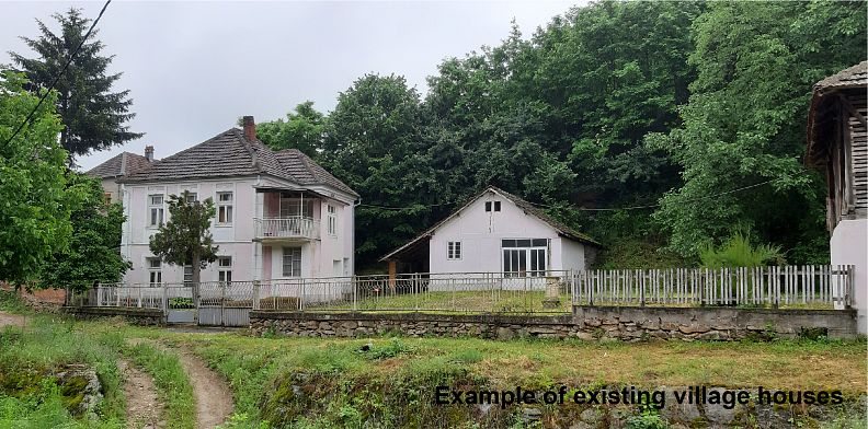
The settlement is of a compact type, with an irregular urban matrix. Relief can be divided into three parts - plain on the river bank, covered with arable land; the foot of the mountain, mild slope, on which there is a settlement and a mountainous landscape covered with dense forest. The settlement is made of fertile land and floodplain physically separated by railway and municipal way. The range of different content is over non-existent, the purpose of housing is dominant, while they are public functions that once existed (railway station, ambulance, veterinary station, primary school, trade shop) extinguished.
CONCEPT
Connecting existing natural and built units in a unique complex by regenerating space and introducing new content and activities.
GOALS
G1 Revitalization of the construction fund
G2 Creating a place identity
G3 Sustainable development of the local community
G4 Positioning of Trubarevo on the map of research centers and tourist places of Serbia
G5 Raising the level of education of Ćićevac municipal residents
G6 Raising the quality of life of Trubarevo residents and of the municipality of Ćićevac
MEASURES
M1 reactivation of the existing railway station "Staro Trubarevo"
M2 paving roads inside the village
M3 construction of a bicycle path that connects the village and the river
M4 formation of pedestrian routes within the village
M5 formation of hiking / mountaineering trails on the mountain (through
forest)
M6 formation of a public parking area
M7 creating new public spaces for outdoor and public living
events (park / square / summer houses)
M8 construction of sports fields and children's playgrounds
M9 formation of a lookout on the mountain (in the forest)
M10 formation of a bathing area on the South Morava river
M11 conversion of an existing family house into a restaurant / cafe
M12 setting up a tourist info point
M13 reactivation of the existing health clinic
M14 reactivation of an existing veterinary station
M15 establishment of a cultural center
M16 conversion of existing family houses into capacities for
temporary accommodation of visitors
M17 conversion of the existing primary school and family houses in
teaching and research spatial units
M18 formation of teaching and research spatial units on
outdoors (in the woods, on the river, in the field)
Project description
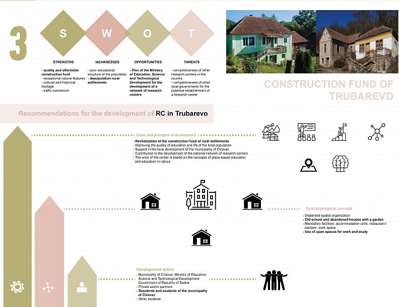
GOALS AND PRICIPLES OF DEVELOPMENT
The main goals that the Research Center in Trubarevo should achieve
are:
- revitalization of the construction fund of rural settlements;
- improving the quality of education and the lives of the local population;
- support in the local development of the municipality of Ćićevac;
- contribution to the development of a national network of research centers.
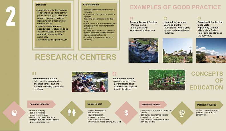
The work of the center is based on concepts of place-based education and nature education.
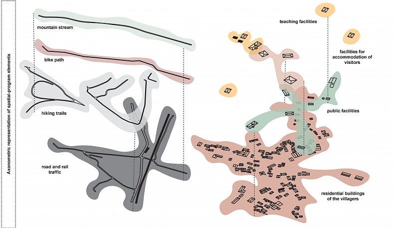
SPATIAL-PROGRAM CONCEPT
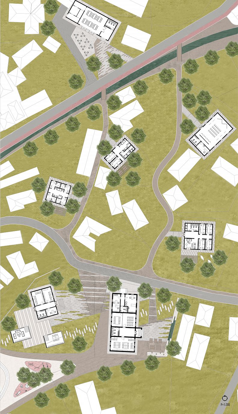
The existing construction fund, the revitalization of which is forming a research fund the center dictates a dispersed spatial organization. The complex consists of an old school building and abandoned family houses and backyards. The facilities in the objects are arranged according to their spatial capacity and mutual position, provided that the school building it is the main place for work and teaching, and the houses are used for accommodation and other facilities.
Mandatory facilities are multi-day accommodation units, restaurant / canteen, space for learning and work, toilets, administration rooms. The research center also uses open spaces that serve as a field for learning and research.
DEVELOPMENT ACTORS
The research center is established by the Municipality of Ćićevac, under the auspices of the Ministry Education, Science and Technological Development and the Government of the Republic of Serbia. The center is funded from the state budget, partnerships with the private sector, donations and available funds of the European Union. In employment and participation in the implementation of the activities of the center
residents of the municipality of Ćićevac have the advantage. The research center is primarily intended for primary and secondary school students from the territory of the municipality of Ćićevac, and then
other students.
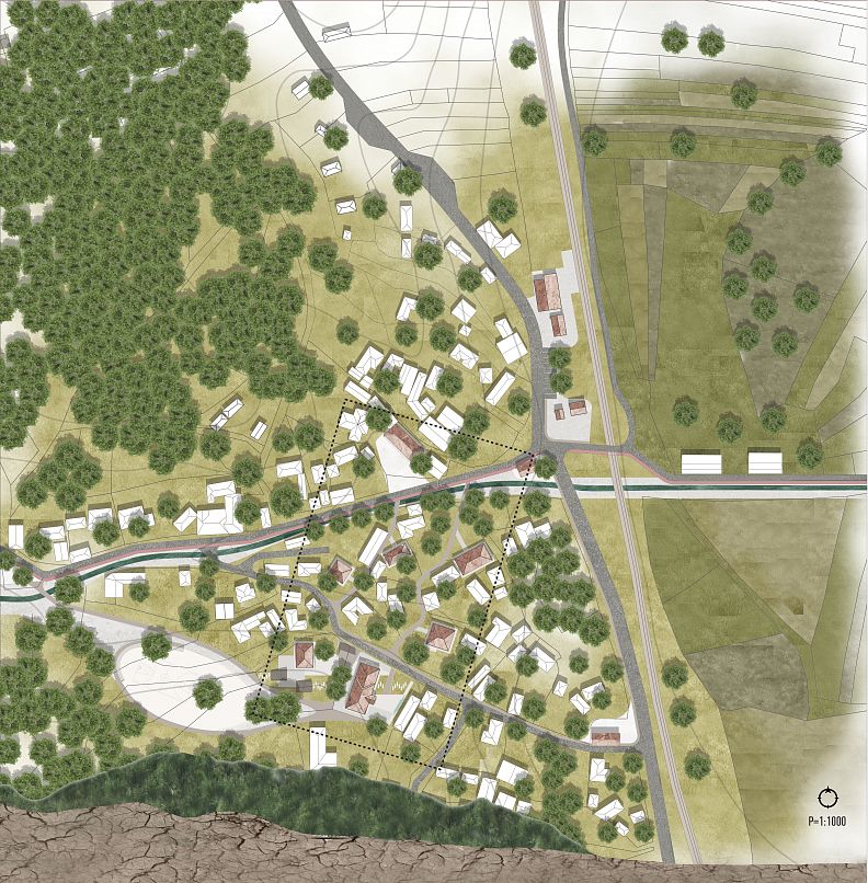
After determining the adequacy of the natural characteristics and the existing infrastructure of the place for the development of the research center, it was carried out analysis of the required minimum space capacities for teaching and accommodation of students and teachers. Shown spatial units can be dispersedly implemented in existing facilities and combined within them according to the given capacities of rural houses.
The combination of spatial units forms a complex in which the teaching center is located in the existing building of the primary school in Trubarevo represents the central object. Existing farmhouses accommodate ancillary facilities such as dining and lodging or extra space for teaching activities. The contents are distributed and combined according to the capacities of the given rural houses, while the rural school is a fixed element of the complex.
By combining the existing and introducing new contents, purpose zones are formed. With their diversity and overlaps, they gained life in the settlement on quality and new opportunities for development open up. The intended purposes are: housing, education, sports and recreation, service activities and traffic.
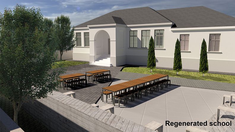
The creation of the complex begins with the placement of educational content in the elementary school's object and a neighboring house. The public space that surrounds them is arranged for teaching outside, but also as a central public space of the village for gathering and different
manifestations. Walking paths lead from the school to the village houses adapted for accommodation of research center users. The road further leads to the cultural center and on end to a cafe-restaurant where users of the research center eat, but it also has a public character. As additional contributing content the functioning of the research center and the quality of life in the village in general, are (re)activated health clinic, veterinary clinic, grocery store, train station, info point and bicycle rental place. Roads in the village are they are asphalting, pedestrian paths are being created that connect these contents, and they are also being introduced a bike path that leads through the village to the river. The public space around the school is connected to the main road inside the village and the mountain stream with the newly created surface which consists of sports fields, children's playgrounds and park space.
Technical information
During the development of this project, was used:
Regional spatial plan for the area of Šumadija, Pomoravlje, Raška and Rasina administrative district;
Spatial plan of the municipality of Ćićevac;
Action plan of the strategy of sustainable development of the municipality of Ćićevac;
Strategy of sustainable and integral urban development of the Republic of Serbia until 2030;
Vision of a small town in Central Europe 2020;
Creative-based Strategies in Small and Medium-sized Cities: Guidelines for Local Authorities ;
Lynch, K. (1960). The Image of the City, Cambridge: The M.I.T. Press;
Radović, D. (2014). Subjectivities in Investigation of the Urban: The Scream, the Shadow and the Mirror, Tokyo: flick studio;
Sobel, D. (2004). Place-Based Education: Connecting Classrooms and Communities, Great Barrington: The Orion society;
Copyright © 2026 INSPIRELI | All rights reserved. Use of this website signifies your agreement to the Terms of Use, Privacy Policy, and use of cookies.
